The Acreage Trap
Bird Hunters May Find Far Less Huntable Ground This Fall
On paper, it can look like a great year to hunt birds in the West.
The maps are full of public access. Walk-in programs advertise hundreds of thousands — in some states, millions — of acres of private land open to hunters. CRP still covers enormous portions of the Great Plains. The opportunity appears to be there.
But there is a problem that doesn’t show up very well on a hunting atlas.
Not all accessible acres are huntable acres.
And in a drought year, the difference can be enormous.
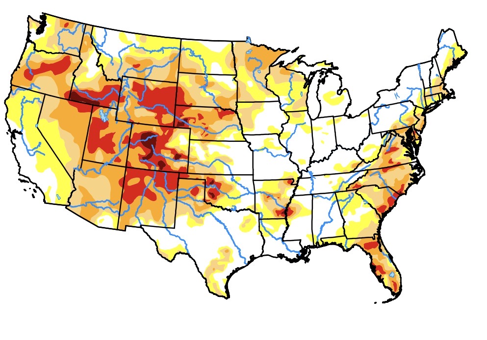
Across much of the Great Plains and West, persistent drought has left agricultural producers short of forage. USDA has responded by authorizing emergency haying and grazing on eligible CRP acreage in drought-stricken counties.
For the farmer or rancher, this is exactly what the program is designed to do.
For the upland bird hunter, however, the consequences can be substantial.
A very common arrangement across the many upland bird ranges is for a private property to be enrolled simultaneously in the federal Conservation Reserve Program and a state walk-in hunting program. The landowner receives a CRP payment to maintain conservation cover and a separate payment from the state for allowing public hunting access.
Under normal conditions, that can be a productive arrangement.
CRP provides habitat. The state provides public access.The landowner receives compensation. And hunters get access to grassland that would otherwise be private.
Everybody wins.
Until drought changes the equation.
When USDA authorizes emergency haying or grazing on CRP ground, a landowner who needs forage has a powerful incentive to use it. And in a severe drought, that decision is understandable. But once that field is hayed, something important has changed. The property may still appear on the state’s walk-in map. The boundary signs may still be there. The acreage may still count toward the state’s advertised total.
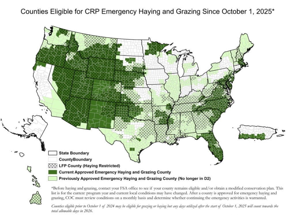
But for an upland bird hunter, it may no longer be viable. The roosting cover is gone. The overhead concealment is gone.
The structure that provides winter cover is gone. Much of the habitat that makes a CRP field valuable to upland birdsl has effectively disappeared.
In practical terms, an acre of hayed CRP may still be an acre of legal public access, but it is no longer an acre of quality upland bird habitat.
That distinction matters enormously to hunters traveling from out of state.
A hunter planning a trip to Kansas, Montana. Nebraska, South Dakota or North Dakota may see hundreds of thousands of acres of walk-in access advertised by the state. They may spend thousands of dollars on licenses, lodging, fuel, food, dogs and equipment based partly on the expectation that enormous amounts of public-access habitat will be available.
But many hunters don’t know how much of that acreage has been altered by drought management.
And that creates the acreage trap.
The map says one thing. The conditions on the ground say another. A property can still be listed as public hunting access even after the habitat has been hayed or grazed.
And unless a hunter has been following local drought conditions, checking individual property updates or physically scouting the area, there may be no obvious indication that the area they drove hundreds of miles to hunt has been mowed down.
This is particularly problematic because emergency haying and grazing aren’t occurring in isolation.
This tends to occur precisely when conditions are already difficult for birds. Drought reduces nesting success. Dry conditions reduce insect production, which is particularly important for young chicks. Poor vegetation reduces brood-rearing cover. Water becomes scarce. And the overall carrying capacity of the landscape declines. Then some of the remaining grassland is hayed or grazed to provide emergency forage.
The result is a shrinking pool of usable habitat.
And that creates another problem: hunter concentration.
Suppose a state advertises 1 million acres of walk-in access in a region. If drought and emergency haying or grazing render a substantial portion of those acres unattractive or ineffective for upland hunting, hunters don’t simply disappear. They move.
They concentrate on the remaining properties with good cover. And that means the remaining habitat receives disproportionate hunting pressure. A property that might normally see a manageable number of hunters can suddenly become one of the few green spots on the map.
The birds are already dealing with poor production and reduced habitat. Now they are dealing with more hunters. The pressure compounds.
This is one of the least visible consequences of drought for traveling upland hunters. The problem isn’t necessarily that a state has lost public access. The state may still have exactly the same number of legally accessible acres.
The problem is that it has lost functional access.
There is a tremendous difference between having a million acres where a hunter can legally walk and having a million acres of habitat that actually holds birds.
That distinction is becoming increasingly important as drought persists across the region.
The federal Conservation Reserve Program is an important source of grassland for upland birds. At the beginning of 2026, more than 26 million acres were enrolled nationally, including millions of acres across the central Great Plains.
At the same time, state wildlife agencies have built enormous private-land access systems around that landscape.
Kansas WIHA.
South Dakota WIA.
Nebraska Open Fields and Waters.
North Dakota PLOTS.
Those programs are a major reason nonresident hunters are willing to travel. They create an expectation that a hunter can arrive in a state, open the atlas and have an enormous amount of land to work with.
But acreage on a map is only useful if there is something worth hunting on it. And that is where this year’s drought deserves much more attention from hunters planning western trips.
The question shouldn’t simply be: How many acres does this state have enrolled in its walk-in program?
The better question is: How many of those acres still have the habitat conditions necessary to hold birds? That information is much harder to find.
Drought doesn’t necessarily eliminate the birds. It can compress them. Emergency haying doesn’t necessarily eliminate public access. It can compress the usable portion of that access.
| State | State Private Access Program Name | Enrolled Private Access Acres (Approx.) | Total State CRP Enrolled Acres (Approx.) |
| Montana | Block Management Program (BMP) | 7,000,000+ | 1,550,000 |
| Wyoming | Hunter Management & Walk-In Access | 2,500,000+ | 650,000 |
| South Dakota | Walk-In Area (WIA) / CHAP / CREP | 1,400,000+ | 1,650,000 |
| Kansas | Walk-in Hunting Access (WIHA) | 1,150,000+ | 1,850,000 |
| Nebraska | Open Fields and Waters (OFW) | 1,000,000+ | 1,600,000 |
| North Dakota | Private Land Open To Sportsmen (PLOTS) | 880,000 | 1,100,000 |
| Colorado | Walk-In Access (WIA) Program | 200,000+ | 1,750,000 |
| Pennsylvania | Hunter Access Program | 2,000,000+ (Includes forestlands) | 120,000 |
| Texas | Public Hunting Program (Walk-In) | 350,000+ (Private tracts) | 2,200,000 |
| Idaho | Large Tracts & Access Yes! | 400,000+ | 450,000 |
| Oregon | Access & Habitat (A&H) Program | 800,000+ | 400,000 |
| Minnesota | Walk-In Access (WIA) Program | 30,000 – 35,000 | 1,000,000 |
| Iowa | Iowa Habitat and Access Program (IHAP) | 30,000+ | 1,650,000 |
| Missouri | Missouri Recreational Access Program (MRAP) | 70,000+ | 750,000 |
| Wisconsin | Voluntary Public Access (VPA-HIP) | 35,000+ | 200,000 |
| Michigan | Hunting Access Program (HAP) | 30,000+ | 110,000 |
| Oklahoma | Oklahoma Land Access Program (OLAP) | 90,000+ | 550,000 |
| Washington | Private Lands Hunting Opportunities | 1,000,000+ (Includes timber land) | 1,100,000 |
| Utah | Walk-In Access (WIA) & CWMU | 150,000+ | 150,000 |
| Ohio | Ohio Landowner-Hunter Access (OLHAP) | 30,000+ | 220,000 |